Source Institutions
Source Institutions
Add to list Go to activity
Activity link broken? See if it's at the internet archive
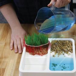
This activity models some of the ways natural processes, such as erosion and sediment pollution, affect Earth’s landscape. Data collected from satellites, such as the joint NASA/USGS Landsat satellites, help improve our understanding of Earth’s land cover. Orbiting Earth, these satellites monitor changes to land cover to help scientists predict changes due to runoff and erosion, and plan for the future. Activity includes a facilitation guide with potential misconceptions, Earth & space science infosheets with NASA connections, table sign, and activity & content training videos. All public-facing materials also available in Spanish.
- Under 5 minutes
- 5 to 10 minutes
- Over $20 per group of students
- Ages 4 - adult
- Activity, Model
- English, Spanish
Quick Guide
Materials List (per group of students)
- Small double-sided paint tray
- Aquarium pebbles (about 5 pounds)
- Plastic aquarium plant
- Small net (“berry net”)
- Pitcher
- Water
- Blue food dye (optional)
- Microfiber cloth or sponge
- Larger tray (cafeteria style)
- Sign, sign stand, information sheets, and activity and facilitator guides
- GLOBE Observer postcards
- “Map Your Backyard Land Cover!” worksheet
- “Tips for Leading Hands-on Activities” sheet
Subjects
-
Earth and Space Science
-
Earth Processes
- Weather and Climate
-
Earth Structure
- Rocks and Minerals
- Oceans and Water
- Biosphere
-
Earth Processes
Informal Categories
- Citizen Science
Audience
Learning styles supported:
- Involves hands-on or lab activities
Other
Foreign language versions of this resource:
- Spanish: Activity Guide (Spanish)
- Spanish: "Looking Down on Earth" Info Sheet (Spanish)
- Spanish: Landslides (Spanish)
- Spanish: Table Sign (Spanish)
- Spanish: "Map Your Backyard" Worksheet (Spanish)
Components that are part of this resource:
- Facilitator Guide
- Activity Guide
- "Looking Down on Earth" Info Sheet
- "Landslides" Info Sheet
- "Map Your Backyard" Worksheet
- Table Sign
- Globe Observer Handout
- Activity Training Video
- Content Training Video
Access Rights:
- Free access
By:
Rights:
- Creative Commons: Non-commercial Share Alike (by-nc-sa), Sciencenter, 2019
Funding Sources:
- NASA, NNX16AC67A
- NASA, 80NSSC18M0061