Search Results
Showing results 1 to 6 of 6
To Topo Two
Source Institutions
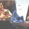
In this activity, two groups of learners create two separate landform models out of clay (mountains and valleys).
Plant Patterns
Source Institutions
In this outdoor mapping activity, learners explore where plants grow and map plant-distribution patterns.
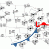
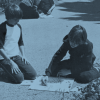
Drawing Conclusions
Source Institutions
In this weather forecasting activity, learners determine the location of cold and warm fronts on weather plot maps.

Energy Use in the Americas
Source Institutions
Learners explore the relationship between energy consumption, population, and carbon emissions in the countries of the Americas.
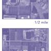
Aerial Imagery
Source Institutions
This activity (on page 2 of the PDF under SciGirls Activity: Earthquakes) is a full inquiry investigation into aerial imagery.
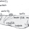
Habitats of the Pond
Source Institutions
In this outdoor activity/field trip, learners locate and study plants and animals in several freshwater pond habitats.