Search Results
Showing results 1 to 10 of 10
Wind Mapping with Bubbles
Source Institutions
Discover the wind's direction using bubbles, a map and a keen eye. Learners blow bubbles and note their general direction on a map, taking readings from different points around a building.
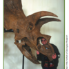
Supersize That Dinosaur
Source Institutions
In this activity, learners explore the size and scale of dinosaurs. Learners listen to "The Littlest Dinosaurs" by Bernard Most. Then, learners estimate the size of a Triceratops and T.
Earth Walk
Source Institutions
In this hands-on and feet-on excursion, learners take a science walk to visualize the planet's immense size and numerous structures, without the usual scale and ratio dimensions found in most textbook
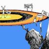
Getting There!: Navigation and Trajectory
Source Institutions
In this two-part activity, learners map a navigation plan to get from Earth to Mars and back. In activity one, learners represent the orbital paths of Earth through dance and dramatic movement.

Tree Trunk Diameter to Branch Height Relationship
Source Institutions
In this activity (located on page 2 of the PDF under GPS: Temperate Rain Forest Activity), learners will identify a group of deciduous trees to study.
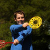
Origami Flying Disk
Source Institutions
In this three-part activity, learners use paper to explore Bernoulli's Principle — fast-moving air has lower pressure than non-moving air.
Shadow Play
Source Institutions
In this three part activity, learners explore and experiment with shadows to learn about the Sun's relative motion in the sky.
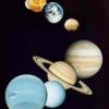
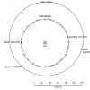
The Thousand-Yard Model
Source Institutions
This is a classic exercise for visualizing the scale of the Solar System.

How Big Were the Dinosaurs?
Source Institutions
In this activity (located on page 4 of PDF), learners gain insight into the actual size of dinosaurs and practice making estimations and measurements.
Four of the States of Matter
Source Institutions
This kinesthetic science demonstration introduces learners to four states of matter: solid, liquid, gas, and plasma.