Search Results
Showing results 1 to 4 of 4
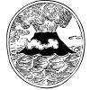
Lava Layering: Making and Mapping a Volcano
Source Institutions
In this activity, learners discover how geologists use stratigraphy, the study of layered rock, to understand the sequence of geological events.
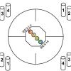
Particle Detection
Source Institutions
By tossing, collecting, and sorting beanbags, learners understand how the IBEX spacecraft uses its sensors to detect and map the locations of particle types in the interstellar boundary.
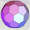
Using Different Models of Earth
Source Institutions
In this activity, learners explore how the shapes, sizes, and distances of land masses appear differently on two different models of Earth: an icosahedron and a flat map.
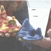
To Topo Two
Source Institutions
In this activity, two groups of learners create two separate landform models out of clay (mountains and valleys).