Search Results
Showing results 21 to 26 of 26

Energy Use in the Americas
Source Institutions
Learners explore the relationship between energy consumption, population, and carbon emissions in the countries of the Americas.

If Anyone Can, Icon
Source Institutions
In this activity, learners create their own icons for a forecast-at-a-glance poster for their classroom/learning space.
Where on Earth?
Source Institutions
Learners look at labels on items in the room to determine where each item was manufactured, then write about the item on an index card.
Tourist Town: Dominating Sets
Source Institutions
In this activity, learners use a fictitious map of "Tourist Town" and counters to problem solve how to place ice-cream vans on street intersections so that every other intersection is connected to one
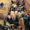
Where in the World is the Terra Cotta Army?
Source Institutions
In this activity, learners find Xi'an, the archaeological area in China where the Terra Cotta Army was discovered, on a map or globe and look more closely at the relationship of the warrior site to ot
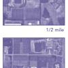
Aerial Imagery
Source Institutions
This activity (on page 2 of the PDF under SciGirls Activity: Earthquakes) is a full inquiry investigation into aerial imagery.