Search Results
Showing results 1 to 3 of 3
Map That Habitat
Source Institutions
Historically, sea floor mapping (bathymetry) was done by soundings.
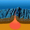
Mid-Ocean Ridge Spreading
Source Institutions
In this earth science activity (page 14 of the PDF), learners use layers of closed-cell foam to create their own model of the mid-ocean ridge in order to simulate seafloor spreading.
Crumple a Watershed
Source Institutions
Learners gain an intuitive knowledge of the physical aspects of watersheds by creating their own watershed models.